V okolí
obuv ¤,
oblečenie ¤,
park ¤,
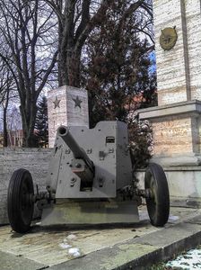
Obetiam 2. svetovej vojny ¤,
parkovisko ¤,
Reformovaný zborový dom ¤,
parkovisko ¤,
parkovisko ¤,
kvetinárstvo ¤,
parkovisko ¤,
Sečovce ¤,
radnica ¤,
parkovisko ¤,
parkovisko ¤,
Domino ¤,
tenis ¤,
nanebovzatia Panny Márie ¤,
autoservis ¤,
parkovisko ¤,
Všeobecná úverová banka ¤Ulice v okolí
Hrnčiarska ¤,
Vysoká ¤,
SNP ¤,
Okružná ¤,
Obchodná ¤,
Potočná ¤,
Bačkovská ¤,
Sedlárska ¤,
Pribinova ¤,
Komenského ¤,
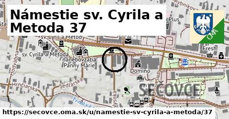
Námestie sv. Cyrila a Metoda ¤,
Dargovských hrdinov ¤Zastávky v okolí
Sečovce,,aut.st. 3 ¤,
Sečovce,,aut.st. 2 ¤,
Sečovce,,aut.st. 1 ¤,
autobusová zastávka ¤,
autobusová stanica ¤,
Sečovce,,aut.st. 4 ¤,
Sečovce,,aut.st. 5 ¤,
Sečovce,,aut.st. výstup ¤,
autobusová zastávka ¤,
Sečovce,,aut.st. 6 ¤Iné čísla
Námestie sv. Cyrila a Metoda 35 ¤,
Námestie sv. Cyrila a Metoda 39 ¤,
Námestie sv. Cyrila a Metoda 33 ¤,
Námestie sv. Cyrila a Metoda 45 ¤,
Námestie sv. Cyrila a Metoda 31 ¤,
Vysoká 10 ¤,
Námestie sv. Cyrila a Metoda 43 ¤,
Námestie sv. Cyrila a Metoda 47 ¤,
Vysoká 9 ¤,
Námestie sv. Cyrila a Metoda 49 ¤,
Námestie sv. Cyrila a Metoda 32 ¤,
Námestie sv. Cyrila a Metoda 27 ¤,
Námestie sv. Cyrila a Metoda 28 ¤,
Námestie sv. Cyrila a Metoda 51 ¤,
Námestie sv. Cyrila a Metoda 34 ¤,
Námestie sv. Cyrila a Metoda 30 ¤,
Námestie sv. Cyrila a Metoda 26 ¤,
Námestie sv. Cyrila a Metoda 77 ¤,
Námestie sv. Cyrila a Metoda 75 ¤,
Námestie sv. Cyrila a Metoda 25 ¤Viac o adrese
Viac info:
aktualizovať mapu,
uprav v JOSM (pokročilé),
-62945426,
stiahni GPX, cislo: 37, streetnumber: 48 37, ulica: Námestie sv. Cyrila a Metoda, ulica asci: namestie sv cyrila a metoda, postcode: 078 01, city: Sečovce, oblast asci: secovce, lon: 21.65316685, lat: 48.702357850000006,
Zdroj dát
Mapové údaje pochádzajú z
www.OpenStreetMap.org, databáza je prístupná pod licenciou
ODbL.

Mapový podklad vytvára a aktualizuje
Freemap Slovakia (www.freemap.sk), šíriteľný pod licenciou CC-BY-SA. Fotky sme čerpali z galérie portálu freemap.sk, autori fotiek sú uvedení pri jednotlivých fotkách a sú šíriteľné pod licenciou CC a z wikipédie. Výškový profil trás čerpáme z
SRTM. Niečo vám chýba?
Pridajte to. Sme radi, že tvoríte slobodnú wiki mapu sveta.